1.1. intervention
area
The Community initiative
URBAN II is a programme covering the development and the application of
particularly innovatory strategies which aims at durable socio-economic
city and agglomeration regeneration in crisis. It also covers the reinforcement
and the exchange of knowledge and of experiences in relation to durable
urban regeneration within the Community.
The urban regions
to which the Community initiative URBAN II addresses itself have to present
certain problems inside a coherent geographical area, such as a high unemployment
rate, a low economic activity ratio, a particularly deteriorated environment,
the specific needs for restructuring, etc.
Under this programme,
the City of Heraklion proposes as an intervention area the geographical
area including Agia Triada's and Kaminia's districts, as well as approximately
half of the Agio district mined (area adjacent to the ramparts and finishing
to the Martinengo bastion).
The intervention
area in question presents, in addition to the demographic requirement (20
000 inhabitants), one degree of considerable homogeneity from the point
of view of the geographical, social and economic characteristics, which
proves the need to select it.
Considering the
city of Heraklion as a whole, according to his current development level,
it is noted that, all around its urban centre, and in particular in the
part located inside the ramparts, there are deteriorated cores from the
point of view of the economic activity and from the housing conditions.
These cores maintain however the traditional urban fabric in spite of the
modern plans of alignment of the streets which were adopted .
One of the cores referred to above,
which certainly is the most important one from the point of view of homogeneity
and from the problems, one of the intervention areas is. This involves the
area of Agia Triada , which covers the north-west part of the historical
city intra muros. This area includes or is in contact with important monuments
of the city, and is directly connected with its history and with its development.
It is surrounded by the Kalokairinou,
Giamalaki, Paraliaki streets Leoforos (Venizelou) and Archiepiskopou Makariou.
As a whole, Agia Triada's area constitutes one of the 25 districts of the
ille v of Heraklion and, more particularly, one of the five districts which
are inside the Venetian ramparts.
For the Ottoman period, Agia Triada's
area had a rather loose structure. At the end of the XIX e century
and at the beginning of the XX e century, factories and warehouses
were built, where the principal agricultural products of the department
(grapes, wine, oil) were processed and were stored. The area acquired a
craft-based and industrial character thus clearly. Near the factories, houses
were built, where those which, refugees for the majority, constituted the
manpower of this first industrial core of Heraklion settled.
Environmental pollution
of the area is particularly substantial on the coast, where of major industrial
units concentrated, and where himself t enait so far the market to the vegetables
of the Heraklion urban complex. At this place, the deterioration is due
to the pollution of the historical and picturesque gulf of Dermatas, caused
by sewers, to the presence of large abandoned buildings (public electricity
company, buildings of craft enterprises , tobacco factory), as well as to
the existence, until a recent time, of noisy and awkward activities (market
to the vegetables, working sites).
The deteriorated
part of the Agio district undermined present the same characteristics
as that of Agia Triada, in a point such as it makes it possible to incorporate
it, for operational purposes, into a single entity forming a homogeneous
area. It is noted, moreover, that the deteriorated part of Agios mined has
higher homogeneity with Agia Triada's district that with the remainder of
the Agio district mined, which is not in prey to the same problems. Environmental
pollution is strengthened by the concentration of immigrants who, profiting
from the low rents, create concentrations gradually and set up family networks,
which has as a consequence an intensification of social polarisation within
the area.
The Kaminia area
constitutes one of the most deteriorated urban entities of the Heraklion
urban complex. With Agia Triada's and Agios's districts mined, Kaminia constitutes
a pocket of homogeneous deterioration the economic regeneration of which
is judged essential.
According to the
general urban plan, the area is delimited in the north by the coast, in
the east by the Venetian ramparts (Agios Andreas's and Pantokrator's bastions),
in the south by the street 62 Martyron, and in the west by the Giofyros
river. According to the descriptions of travellers (Praktakidis 1818, Kalomenopoulos
1894, etc.), the area has its current name to an old lime kiln (en grec,
"" asvestokamino"") on the side of the Eleftherias street.
During the interwar years, exchangeable grounds, intended for the Greek
refugees' reinstalment in rural and urban areas, were distributed. Thus,
non distributable grounds, located along the ditch, of the Pnevma Agio fortification
and of the coast, were occupied by private individuals who built improvised
dwellings. The stage of the sportsman Circle of Heraklion was builds in
the area of the cemeteries, while of the workshops and warehouses were set
up along the coast and in the street 62 Martyron. Lastly, after 1980, the
pressing needs for housing, that the extension of the urban plan towards
the west does not manage to satisfy, cause illegal constructions.
The need to regenerate
the Kaminia area does not concern solely the coast of the district which
already presents acute elements of deindustrialisation . Inside the area,
the deterioration is had mainly to the bad quality of the infrastructure
and to the absence of common spaces reserved for the sporting and of leisure
activities.
1.2 basic characteristics and demographic data
Unfortunately, the
census carried out on a national scale in March 2001 has not produced yet
concrete data on the population of the area. According to the census of
1991, the studied area has a population of 14,338 inhabitants (on a total
population of 132,137 for the city, which accounts for therefore approximately
11 %). However, the real population is more important and is considered
at approximately 20,000 inhabitants, on a total population considered at
150,000 inhabitants. This increase is due to the fact that a decade has
passed since and that the urbanisation of the area continued.
Like some other
large cities of the country, the studied area was the subject of research
of the Thessaly University, which was completed three years ago and the
results of which are exposed below.
As regards the population
pyramid, the presence of a high percentage of old people is noted, while
the percentage of young individuals is low and decreases constantly. In
other words, there is an unhealthy relationship between the extreme layers
of the population pyramid.
This phenomenon
is allotted to the incapacity of the area to preserve the part of its most
dynamic population from a economic point of view. The difficulties noted
in the economic and social development of the area encouraged a good many
of young people to be moved house towards other more developed areas, inside
or outside Heraklion.
table 1.1
| STRUCTURE DE LA RÈGION ÈTUDIÈE | ||
|---|---|---|
| CHIFFRES ABSOLUS |
POURCENTA |
|
| POPULATION RÈELLE | 14.338 | 100% |
| POPULATION ACTIVE |
5.220 | 36% |
| POP. ÈCONOMIQUEMENT ACTIVE |
5.191 | 36% |
| CHÔMEURS | 445 | 9% |
| ÈTRANG | 79 | 1% |
diagram 1.1
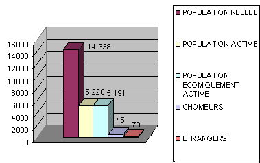
Source: Laboratory of space analysis and of subject map-making of the Thessaly University
table 1.2
|
TRANCHES D'ÄGE ( POP. ACTIVE ) - ÈTUDIEE |
||
|---|---|---|
| EN % |
CHIFFRES ABSOLUS |
|
| 0-14 ANS |
0% |
16 |
| 15-24 |
16% | 846 |
| 25-34 |
30% | 1585 |
| 35-44 |
25% |
1325 |
| 45-54 |
17% | 911 |
| 55-64 |
9% | 484 |
| 65-ΑΝΩ |
1% | 55 |
Source: Laboratory of space analysis and of subject map-making of the Thessaly
University
diagram 1.2
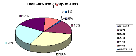
Source: Laboratory of space analysis and of subject map-making of the Thessaly University
1.3 analysis
of the socio-economic situation, of the structures and of the environment
The training level of the inhabitants
is, in general, rather low, certainly more than the average of the city
(on the basis of the data provided by the social welfare). There is a very
high rate of illiterates and of persons who even did not finish obligatory
teaching.
|
NIVEAU D'EDUCTION - ZONE ETUDIEE ( SUR L'ENSEMBLE DE LA POP. ACTIVE ) |
||
|---|---|---|
| EN % |
CHIFFRES ABSOLUS |
|
| UNIVERSITAI |
9% |
484 |
| SUPÈRIEUR |
5% | 273 |
| MOYEN |
25% | 1.292 |
| MOYEN TECHNIQU |
6% |
289 |
| OBLIGATOIRE |
9% | 484 |
| ELEMENTAIRE |
40% | 2.113 |
| NON ELEMENTAIRE |
5% | 285 |
TABLE 1.3.
Source: Laboratory of space analysis and of subject map-making of the Thessaly University
DIAGRAM 1.3.
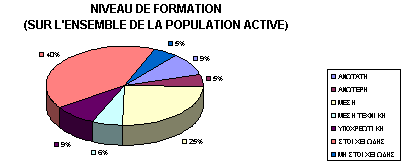
Source: Laboratory of space analysis and of subject map-making of the Thessaly University
The manpower of the area accounts for 36.15% of
the whole of the population, while official unemployment amounted, in 1999,
to almost 10% of the working population, i.e. an appreciably more important
rate than that of the remainder of the city (8 %). the economically active
population structure is characterised by an important proportion of workmen,
of commercial employees and of office workers (58% of the total). The other
economic characteristics of the area are weak incomes with very weak, a
population composed primarily of workmen, a high percentage of pensioners
and, generally, of old people.
It is certainly revealing that
real unemployment in the studied area is appreciably more important: according
to data of the City of Heraklion, it approaches the 18% owing to the existence
of a non listed and socially marginalised population, which carries out
occasionally ungrateful, in general without Social Security cover and badly
remunerated tasks. Also to point out that numerous individuals are not registered
as unemployed persons because they devote themselves to other forms of occupation,
such as, for example, the use of a small holding, etc.
Population housing conditions correspond to the
general image of deterioration of the area. Certain data of the precaution
services reveals that cheap and abandoned dwellings are used, temporarily
or in a permanent way, by social groups economically disadvantaged, such
as refugees of Greek origin, Gypsies and immigrants coming from the neighbouring
countries, mainly from the Albanians. Also to note that Agia Triada's parish
distributes financial aid, and even of food, to a large number of people
(approximately 100) who are in the need.
With regard to the economic
activity of the area, the appearance of numerous companies will be noted
along the ways which border the area (62 Martyron, Kalokairinou, Archiepiskopou
Makariou, etc.), but these are of especially a supralocal importance, while
contributing to the employment of the inhabitants. However, a summary survey
carried out by the study group to certain units employing more than ten
people revealed that the majority of the employees do not live in the area
in question.
Within the urban fabric, there are small units,
mainly of commercial nature. Their distribution appears in the table below.
The same table also reveals the existence of an increased percentage
of unutilised and dilapidated buildings.
|
|
Ag. Triada |
Kaminia |
TOTAL |
|---|---|---|---|
|
Offices |
35 |
22 |
57 |
|
Shops |
152 |
313 |
465 |
|
Craft -enterprise shops |
20 |
59 |
79 |
|
Workshops |
3 |
39 |
42 |
|
3rd coles |
5 |
9 |
14 |
|
Frontistiria |
3 |
16 |
19 |
|
Municipal public
-buildings |
3 |
7 |
10 |
|
Warehouses |
30 |
76 |
106 |
|
Unutilised buildings |
92 |
177 |
269 |
|
Parks with cattle |
2 |
6 |
8 |
|
Grounds |
36 |
121 |
157 |
|
Dilapidated buildings |
125 |
44 |
169 |
|
Another use |
16 |
39 |
55 |
source : ÉÔÅ (technology and research Institute)
In addition to the fact that the studied area account a number of unemployed of an average training level with satisfactory and relatively young people, this data makes even more imperative the need to implement actions which will encourage the creation and the operation of small enterprises. Support and aid for the small enterprises anticipated by the priority 2 of the programme will provide an impetus to the development of the companies which already perform in the area, while, in parallel, the various actions of the measure 2.1. should contribute to the creation of new companies and/or to the displacement of certain companies of the adjacent areas. In addition to the individual benefits resulting from the measure 2.1., the existence of a considerable number of unutilised buildings constitutes an additional incentive to the installation of new companies in the area. All these processes will cause, in the long term, to revitalise and to develop the area which, one knows it, is currently in crisis.
There are small units, mainly of commercial nature. A considerable concentration of small trade on the Kaminia central place is noted, mainly on the northern side. It is advisable to mention in particular the picturesque area made up by the popular art workshops (mainly in the Vourdoubadon and Mastracha streets), which tend constantly to disappear and which generally close because the young generations do not want to perpetuate the tradition. Lastly, several craft enterprises, workshops, etc, were deployed along the coast. The majority of these units are characterised by an economic improvised administrative organisation and by an obsolete equipping (cf. cards on the economic activity, attached. Source: ITE).
In this context of deteriorated living conditions, the social problems which accumulate are important and of various nature, while existing social Security is rudimentary. On the one hand, there is a high percentage of old people, who concentrate mainly in Agia Triada's area, but the essential structures of social welfare are missing. On the other hand, the participation of women in the improvement of the family income is not favoured owing to the absence of complementary structures, such as, for example, creches, which would enable them to be engaged on new posts. Lastly, there are areas to the periphery of the Kaminia district which show obvious characteristics of environmental deterioration and of delay in socio-economic development. Among the exclusion indexes social in the area, one involves the cases of risk of provisional loss of housing, of maltraitance of women, of deviating behaviour, etc.
At the same time, the various
economic and social problems which often involve problems of family nature
are not managed responsible and systematic manner by an unspecified authority.
The individuals economically disadvantaged do not have the possibility of
benefiting from assistance, if it is not that of the Church or the allocation
meagre of the precaution. In this situation, there are high risks that phenomena
of social exclusion appear.
Young people do not find any
discharge system or any hearth where they could share their concerns and
devote themselves to healthy activities, be helped in the their employment
search and, generally, in their professional reintegration. Lastly, it is
appropriate to point out that the refugees and the foreigners who are concentrated
in the area are regarded as a foreign body insofar as nothing were designed
nor done to bring a solution to their problems.
The deteriorated industrial area which stretches along the coast takes on a special importance with regard to this proposal. In this area rather important sets of industrial buildings, of workshops and of warehouses are, the majority of which are inactive. The concentration of these sets had a decisive influence on environmental pollution of the area and on its marginalisation.
Analysis of the strengths, weaknesses, opportunities and threats (SWOT) of the area
The SWOT table below summarises the strengths, weaknesses, opportunities and threats which characterise the intervention area proposed for the benefit of the URBAN initiative II for Heraklion.
|
|
assets |
weaknesses |
|---|---|---|
|
Present situation |
assets Central position in relation to the important activity poles, existing (downtown area, port) or in the process of creation (Stage all-Crete, Olympic Games 2004). Traditional buildings, inactive but workable property park, elements of historical inheritance. Workable coast. Existing museum. Existence of a pie of buildings belonging to the City.
|
weaknesses High unemployment rate. Problematic population pyramid. Low level of education and of training of manpower. Very reduced average size and delay of the companies. High proportion of foreigners and of Gypsies including the present social integration of the difficulties. Deteriorated property park. Insufficiency of urban and cultural equipment. The city is mainly turned towards the interior of the land and not towards the sea. The coast is deteriorated, not arranged and underexploited. Generally, insulation and particularly negative differentiation in relation to the remainder of Heraklion. |
|
prospects |
OPPORTUNITIES Organisation of eliminatory football and semi-final matches within the framework of the Olympic Games of 2004 at a place bordering (Stage all-Crete). Economic dynamism of the area in the broad sense (remainder of the city, department). Moreover: - a museum is under construction; - it is envisaged moving away from the area a football stage (Heraklion sporting Circle), which will release workable urban space; - it is envisaged that the Organisation of the subsidised housing moves wooden huts (illegal constructions on a usurped ground), which will release the area. |
threats Perpetuation of the economic stagnation of the area, which will involve the creation of a completely marginalised area, since the remainder of the city shows a certain dynamism. Continuation of urban environmental pollution because of the construction of a coastal road way of rapid traffic, in the absence of compensatory interventions of urban and environmental planning. |